(29 Oct 2024)
RESTRICTION SUMMARY:
ASSOCIATED PRESS
New Orleans – 29 October 2024
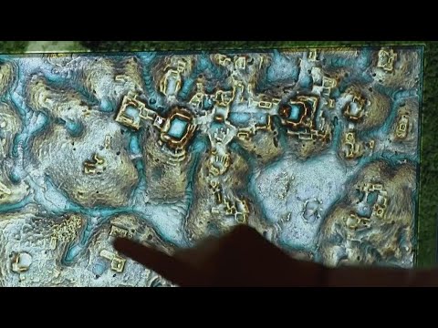
1. Wide of Professor Marcello Canuto showing LiDAR map
++COVERED++
2. SOUNDBITE (English) Marcello Canuto, Director of Middle American Research Institute, Tulane University:
"In these blocks, these different areas that had been investigated, we found like 6,700 structures."
++PARTIALLY COVERED++
3. SOUNDBITE (English) Marcello Canuto, Director of Middle American Research Institute, Tulane University:
"The data that we look in, in these blocks of survey information is remnants of human activity on the landscape. That is buildings that humans built, canals, roads, anything that is not a natural feature."
4. Mid of LiDAR Map
++PARTIALLY COVERED++
5. SOUNDBITE (English) Marcello Canuto, Director of Middle American Research Institute, Tulane University:
"We’re finding LiDAR is helping us with this technology that’s able to penetrate forest canopy and see what’s on the ground below. We’re able to see in places like Southeast Asia, the Amazon and Maya region that these tropical environments had these really complex and relatively large populations living in these regions."
6. Various of LiDAR map
++PARTIALLY COVERED++
7. SOUNDBITE (English) Marcello Canuto, Director of Middle American Research Institute, Tulane University:
"The suggestion from these data would be that were we to expand the survey of this particular region or all other regions we would find more of what we found."
++COVERED++
8. SOUNDBITE (English) Marcello Canuto, Director of Middle American Research Institute, Tulane University:
"We have always been able to talk about the ancient Maya especially in the lowland regions because of their hieroglyphic texts. What we are now able to do is match that information with their settlement and the population and what they were fighting over, what they were ruling over, what they were trading with. It allows us to tell better stories of the ancient Maya people."
9. Various of Middle American Research Institute gallery
10. Various of plastered monument replica
11. Mid of LiDAR map
STORYLINE:
New research published by Tulane University doctoral student Luke Auld-Thomas and his advisor, Professor Marcello Canuto shows more than 6,500 structures found in a jungle near Campeche, Mexico including an unknown city.
The structures date back to nearly 1500 years ago.
The recent findings came with the help of a technology called Light Detection and Ranging (LiDAR) which allows researchers to look through tree canopy and interpret what is on the ground beneath.
"Everywhere where we’re doing LiDAR we’re finding more than what we expected" said Tulane University Professor Marcello Canuto.
Tulane University’s Middle American Research Institute (MARI), which studies indigenous Central America, has been using LiDAR technology for nearly a decade and has built an advanced laboratory to analyze LiDAR data.
The study was published just months before MARI is set to open a renovated gallery exhibiting indigenous Middle American celebrations for the institute’s one hundred year anniversary.
===========================================================
Clients are reminded to adhere to all listed restrictions and to check the terms of their licence agreements. For further assistance, please contact the AP Archive on: Tel +44(0)2074827482 Email: info@aparchive.com.
Find out more about AP Archive: http://www.aparchive.com/HowWeWork
Twitter: https://twitter.com/AP_Archive
Facebook: https://www.facebook.com/APArchives
Instagram: https://www.instagram.com/APNews/
You can license this story through AP Archive: http://www.aparchive.com/metadata/youtube/3c886b5baecb4ea89a227c15988cc61b
Author: AP Archive
Go to Source
News post in November 4, 2024, 12:05 am.
Visit Our Sponsor’s:
News Post In – News


